The Atlantic hurricane season spans from June 1 to November 30 each year. In 2026, the National Oceanic and Atmospheric Administration (NOAA) has forecasted fewer storms, indicating a below-average season. As of now, no active storms are present. For reference, you can view timelines for past years, such as 2024 and 2025.
Previous Storms in 2026
Tropical Storm Arthur
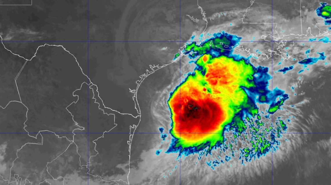
On June 16 at 10 a.m., the National Hurricane Center reported Potential Tropical Cyclone One, located 65 miles southwest of Corpus Christi, Texas. This system had winds reaching 30 mph, moving northeast at 6 mph. By 4 p.m., a Tropical Storm Warning was issued from Sabine Pass to Morgan City, Louisiana.
Tropical Storm Arthur formed on June 17 at 10 a.m., about 40 miles east-northeast of Port O’Connor, Texas, with sustained winds of 40 mph. The storm moved northeast at 9 mph. A warning was issued for the Texas coast extending from High Island to the Louisiana border. Arthur transitioned to a post-tropical cyclone later that day.
Tropical Storm Bertha
On July 19 at 10 a.m., Tropical Depression Two emerged south of Panama City, Florida, with 30 mph winds. By July 20, it evolved into Tropical Storm Bertha, boasting 40 mph winds. Bertha reached maximum strength on July 21, clocking wind speeds at 60 mph.
Bertha made landfall near the Biloxi Wildlife Management Area in Louisiana on July 22. With sustained winds of 45 mph, it continued westward, later weakening on July 23 near Houston, Texas, before dissipating.
Tropical Storm Cristobal
On August 12, Cristobal formed about 880 miles west of the Azores with 45 mph winds. The storm weakened into a tropical depression the next day, eventually becoming a remnant low.
Tropical Storm Dolly
Dolly formed on August 27 east of the Leeward Islands, presenting 40 mph winds. However, it dissipated by August 28, around 1,000 miles east of the Leeward Islands.
Tropical Storm Edouard
On August 31, Edouard emerged as a potential tropical cyclone south of Morgan City, Louisiana. With 35 mph winds, warnings were issued for sections of the Gulf coast. The storm reached maximum strength on September 1 with 60 mph winds and made landfall near Johnson Bayou, Louisiana. It weakened to a tropical depression by September 3.
Tropical Depression Fay
Beginning as a depression southwest of the Azores on September 19, Fay strengthened into a tropical storm with 45 mph winds. After weakening and dissipating, Fay redeveloped and fluctuated between tropical storm and depression status before ultimately dissipating.
Tropical Storm Gonzalo
Formed on September 24 off the Cabo Verde islands, Gonzalo reached 50 mph winds before dissipating by September 26.
Tropical Storm Hanna
On September 28, Hanna developed east-northeast of Bermuda with 45 mph winds, later dissipating by September 30.
Hurricane Isaias
Isaias formed as a tropical depression on October 6 west of Progreso, Mexico. By October 7, it intensified into a Category 1 hurricane, further strengthening to a Category 3 hurricane by October 9. Isaias made landfall later that day near Destin, Florida, and subsequently weakened before transitioning into a post-tropical cyclone on October 10.
 Warnings Issued for Electric Vehicles Following Coastal Floods in Southern California
  Pennsylvania’s Data Center Permit Tracker and the AI Infrastructure Debate
  Winter Heating Costs: What to Expect Amid Historic El Niño
  Tropical Storm Rachel and Coastal Hazards for Southern California
  Hurricane Simon Surges Toward Mexico as Category 4 Storm
  California Faces Unusual Coastal Flooding Amid Predictions of El Niño Winter