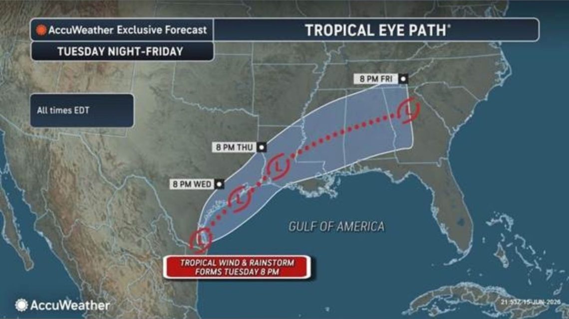
Millions in the Gulf Coast and Lower Mississippi Valley are at risk from potential “life-threatening” flash floods this week. Forecasters are closely watching a weather system near Texas that might briefly turn into a tropical storm. Currently, the disturbance is creating widespread showers and thunderstorms near the Texas-Mexico border. The tropical moisture involved could lead to several days of intense rain.
If a tropical storm forms, it would be named Arthur, the first name on this year’s list. Forecasters highlight that the greatest danger isn’t the wind strength, but rather the heavy rainfall. Persistent tropical downpours could overburden drainage systems, spark hazardous flash flooding, and cause rivers to rise swiftly in areas already saturated.
System Near Texas Could Strengthen
The National Hurricane Center (NHC) reported a trough of low pressure near the Mexico-Texas border producing a broad area of disorganized showers and thunderstorms. According to an early-morning update on Tuesday, this system might move over the northwestern Gulf of America. Environmental conditions there could allow a short-lived tropical storm to form later today or Wednesday.
“Regardless of tropical cyclone formation,” the NHC advised, “interests across southern and eastern Texas and portions of Louisiana and Mississippi should prepare for intense rainfall over the next few days, potentially causing widespread, life-threatening flash, urban, and river flooding.”
Gusty winds and coastal flooding may also impact parts of the northwestern Gulf Coast, with possible tropical storm watches or warnings if development continues.
Why Forecasters Are Worried About Flooding
On Monday, AccuWeather forecasters issued a warning via email to Newsweek about a possible “tropical rainstorm” forming on Tuesday. They stated that this term brings “additional attention to tropical systems that may not officially receive a name but pose a flooding risk.” AccuWeather’s vice president of forecasting operations, Dan DePodwin, emphasized concerns over “repeated rounds of torrential rain fueled by tropical moisture and perhaps a tropical rainstorm.” Similar setups have historically led to significant flash flooding events.
Which Areas Are Most at Risk?
AccuWeather projects heavy rain moving from eastern Mexico through Texas and parts of the Gulf Coast, later tracking northeastward. In the strongest storms, rainfall could be 2 to 4 inches per hour, heightening the risk of rapidly rising water, especially in urban regions like Houston.
Could It Become Tropical Storm Arthur?
As of Tuesday morning, the National Weather Service issued flood watches for southern and southeastern Texas, much of Louisiana, and roughly the southern half of Mississippi.
The Atlantic hurricane season began June 1 and runs through November. This year, the National Oceanic and Atmospheric Administration forecasts a below-normal Atlantic hurricane season, predicting eight to 14 named storms. The NHC continues to track the disturbance and will provide regular updates as the system develops.
 Investigation Underway Following Tragic Incident at Yosemite’s Nevada Fall
  Europe Braces for Severe Heat Wave with Safety Measures
  U.S. Auto Safety Regulator Investigates Fatal Tesla Crash Involving Autopilot
  Abandoned Oil Wells in Illinois: A Persistent Environmental Challenge
  U.S. Fish and Wildlife Service Updates Definition of Shellfish
  Europe Faces Record-Breaking Heat Wave with Severe Impact