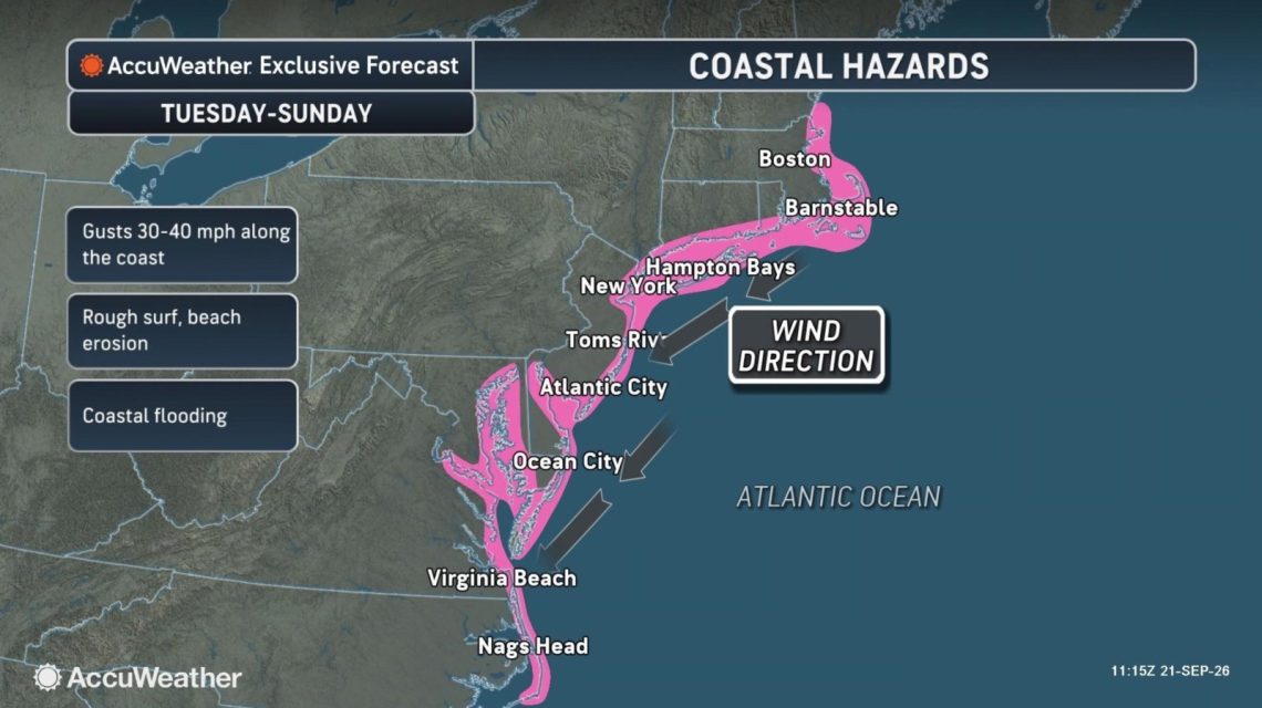
A potential nor’easter could bring heavy rainfall, strong winds, dangerous surf, and flooding to parts of the East Coast this week. However, the exact path and strength of the storm are still uncertain, according to forecasters.
Understanding Nor’easters
Defined by the National Weather Service, a nor’easter is a storm affecting the East Coast of North America, with winds over coastal regions typically coming from the northeast. These storms can occur year-round but are most common and intense from September to April. They generally bring heavy rain or snow, gale-force winds, rough seas, and occasional coastal flooding.
Forecasts and Predictions
The Weather Channel has indicated that an area of low pressure might evolve into a nor’easter off the Northeast coast by the end of the week. This system could lead to travel disruptions along with high surf, rain, wind, and coastal erosion in affected areas.
According to forecasts, an area of high pressure is likely to form near the Great Lakes as the low-pressure system moves north along the East Coast. As these systems approach each other, winds are expected to intensify. Forecast models suggest varying positions for the low-pressure system. One possibility brings the system closer to shore, which may amplify winds and rain, along with increased coastal erosion. Another scenario places the system farther offshore, potentially reducing its impact along the Interstate 95 corridor.
Potential Impacts
AccuWeather has predicted that coastal flooding could affect areas from North Carolina to New York from Tuesday through Friday, with risks possibly extending to the northern Mid-Atlantic coast and southeastern New England over the weekend. The full moon is likely to elevate astronomical tide levels later in the week, which could worsen flooding conditions.
Meteorologist Alex DaSilva from AccuWeather warns that gusty winds, heavy rain, and coastal flooding might still occur across parts of the Northeast and Mid-Atlantic during the latter part of the week and into the weekend. With leaves still on the trees, there is concern for localized power outages, especially in coastal regions where winds might be stronger.
Additional Warnings
FOX Weather forecasts major coastal flooding, extreme surf, and continuous heavy rain in the Outer Banks. Wind gusts could hit 40 to 50 mph, with offshore wave heights reaching 15 to 18 feet. Ocean overwash is anticipated on coastal roads, including Highway 12. Moderate coastal flooding may occur, particularly around high tides and in low-lying coastal areas back bays. States like North Carolina, Virginia, Maryland, Delaware, and New Jersey may see increased tidal flooding, extending into southern New England.
FOX Weather expects the low-pressure center to track north toward the Interstate 95 corridor and New England by the weekend. One possible path could take the low closer to Boston, leading to wind gusts of 60 to 70 mph, heavy rain, a substantial storm surge, and notable disruptions around Boston Harbor and the Massachusetts coast. Alternatively, if the track moves closer to Long Island or New Jersey, stronger effects might be felt farther south. If the low remains offshore, coastal New England could experience rough surf, elevated tides, and breezy conditions, while the strongest winds and heaviest rain stay over the ocean.
 California’s Growing EV Adoption: Challenges and Benefits
  Influencer Brothers Logan and Jake Paul Visit the Pentagon
  Florida Reports First Dengue Fever Death as Outbreak Expands
  American Public Opinion on Press Freedom
  St. Laurence High School’s Transformative Journey
  Significant Events in Chicago History on September 21