Justin White was on his way home with his son, Gavin, in Hebron when a tornado threatened their safety. As they hurried to reach home, Gavin asked if they were going home with the storm. White confirmed, saying they needed to get his wife. He drove onto the lawn, parked the car, and they all sought refuge inside. White managed to capture a short video before the tornado shattered windows, and he joined Gavin in the basement.
The National Weather Service confirmed that tornadoes swept through Northwest Indiana, following their path from Illinois, leaving many without power. Although no fatalities occurred, an EF3 tornado with winds between 136-165 mph wreaked havoc in Kouts. Areas like Merrillville and Hebron faced significant damage as well. Wind gusts reached 76 mph in the Town of Pines and 56 mph in Ogden Dunes, with flooding in Crown Point.
By Friday afternoon, NIPSCO reported 52,603 customers still without power, although they restored power for 95% of the 21,500 affected by Wednesday’s storm. Due to severe destruction, power restoration timelines remain uncertain. For outage reporting, text OUT to 444111, visit nipsco.com/outages, or use the NIPSCO mobile app.
Scott Pelath, leading the Kankakee River Basin and Yellow River Basin Development Commission, inspected river debris to prevent flooding. Though high precipitation occurred recently, severe flooding is not expected.
South Porter County Hit Hard
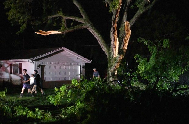
South Porter County experienced extensive damage. Homes along Baums Bridge Road and Ind. 49 in Kouts suffered, as did farmland in Hebron. White recounted the near-disaster at his home. Despite installing wind-resistant roofing, a tree struck his car soon after they escaped. White expressed disbelief at the storm’s intensity.
Ryan Kats, White’s friend, saw damage to his shop and sod farm equipment. Neighbors showed up to help despite never being asked. Edward Schrey, another local, noted how the storm seemed to follow the Kankakee River’s path, sparing his property.
Porter County Sheriff Jeff Balon commended first responders and community members aiding storm victims. More officers will patrol affected areas to deter scams and theft.
Severe Impact in Merrillville
In Merrillville, residents like Maria Williams faced significant losses. Inspecting her damaged home on Friday, Williams described the destruction wrought on the home where her children grew up. Her daughter Kari, caught in the storm, recalled the frightening moment. Without power and with structural damage, their future remains uncertain.
Merrillville’s Andrean High School also faced severe damage. The school’s windows and roof endured harsh treatment, and downed power lines littered the area. Director of Facilities James Myers was shocked by the devastation and has been working to clear debris and prepare for rebuilding.
The town announced over 200 damaged buildings, emphasizing the damage’s residential focus. While assistance is available, one person suffered minor injuries from a semi-truck incident during the storm.
The American Red Cross established a shelter at the Lincoln Center in Highland for those in need, with donations accepted at the Ross Township Trustee’s Office.
Countywide Recovery Efforts
Lake County officers responded to weather-related issues and assisted stranded motorists. Portage faced tree damage and flooding due to overflowing creeks. City services worked through the night to reopen roads and address essential needs.
Portage Utilities Superintendent noted damage to solar panels and limited access to inspect further issues due to power lines.
Transport Disrupted
The South Shore Line suspended service, with crews working into the night to transport stranded passengers. Fallen trees and downed wires caused service interruptions. Gary Public Transportation resumed service later on Friday after road problems were addressed.
The extensive damage and community response highlight the strength and resilience of residents and officials during challenging times.
 Fencing Installed Around Lincoln Memorial Reflecting Pool for Security
  Justice Department’s Record Healthcare Fraud Takedown
  Supreme Court Rules Against Former Inmate’s Religious Rights Claim
  Utah’s Congressional Primaries and New District Map
  Search Continues for Missing Nancy Guthrie
  Search Continues for Missing Giraffe in Texas