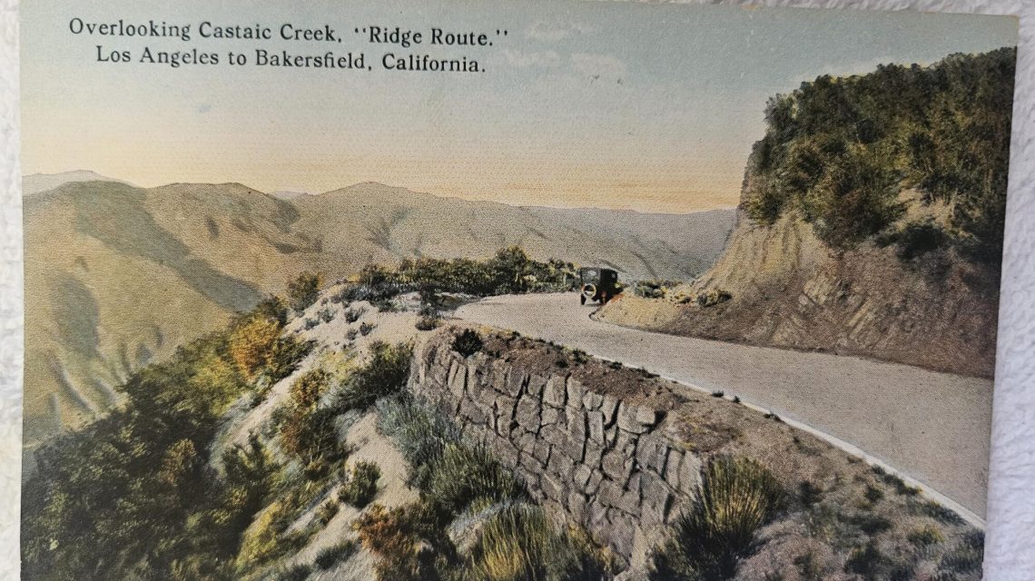
Interstate 5, often referred to simply as “the 5,” is a major artery that runs through California. It connects Southern California to Central California, crossing the Tejon Pass, which stands at 4,160 feet. This pass is crucial in uniting two distinct regions, and there has been talk of splitting the state at this line.
Before the completion of the I-5 in 1970, navigating the pass was challenging. Trucks, tourists, and local travelers encountered steep, sometimes treacherous conditions that were windy, icy, or foggy. While not as tall as other mountain ranges, Tejon Pass presented significant difficulties for those hauling goods over its inclines.
“The Tejon Pass isn’t nearly as tall as its grander sister mountain ranges, but no one has to haul a big rig loaded up with peaches over Mt. Baldy or Mt. Whitney.”
Early routes through the area were known as the Ridge Route. The first was completed in 1915, featuring 697 curves over 36 miles, with a speed limit of 15 mph. Today, parts of the original route remain accessible only to local traffic and occasional antique car clubs. About 18 miles is listed on the National Register of Historic Places, where volunteers work hard to preserve these historic lanes.
Before the roadways, Native Americans lived in the mountains for thousands of years. Spanish soldiers first explored these trails in the 1770s. The Tejon Pass name stems from an encounter with a dead badger by an 1806 expedition.
In 1854, the U.S. Army established Ft. Tejon to monitor Native American activities. It survived a significant earthquake in 1857. During this period, travel was dangerous, and transporting goods involved cumbersome pulley systems on steep grades.
The emergence of notable Californians like Phineas Banning and Andres Pico led to improvements, opening the path for the Butterfield stagecoaches in 1858. Later, Edward Beale deepened the pass to cut through rock completely, allowing passage with ease but charged tolls for travelers.
The first vehicle traveled through the pass in 1902, driven by Ralph Hamlin. Facing fuel delivery issues, he reversed his car up the summit.
In 1910, the Newhall tunnel opened, providing a more manageable route through the mountains but was soon outdated as traffic increased. A more efficient Ridge Route was built in 1916, cutting out hours from trips between L.A. and Bakersfield.
Travelers and workers settled along this road until asphalt improved conditions. The road led to new services — hotels, restaurants, and garages — vital for travelers impeded by weather conditions.
Even in 1931, tragedy struck as a woman’s car crashed into a ravine, highlighting the dangers of early travel. Robbery was another risk, with bandits exploiting the slow travel speeds.
The Ridge Route’s Alternate opened in 1933 but quickly was surpassed by demands. It received upgrades within 10 years but eventually lost out to the development of the I-5.
Today, remnants of the old Ridge Route lie beneath Pyramid Lake. Enthusiasts and preservationists like Sydney Croasmun keep its legacy alive, maintaining this pathway’s historical significance.
The Ridge Route’s history is a tale of travel innovation meeting the demands of modern transportation. Its shadow still casts over the hills, a reminder of the rugged journey to connect California’s vast landscapes.
 How Battery Innovations Transform Renewable Energy
  Data Centers Stir Controversy in Texas Amid Growth Boom
  Lonnie G. Bunch III Reflects on His Legacy at the Smithsonian
  Urgent Archaeological Efforts in Quinhagak Stay Ahead of Erosion
  Concerns Rise Over NIPSCO Permit In Jasper County
  Reader Reactions on Grizzlies and Data Centers