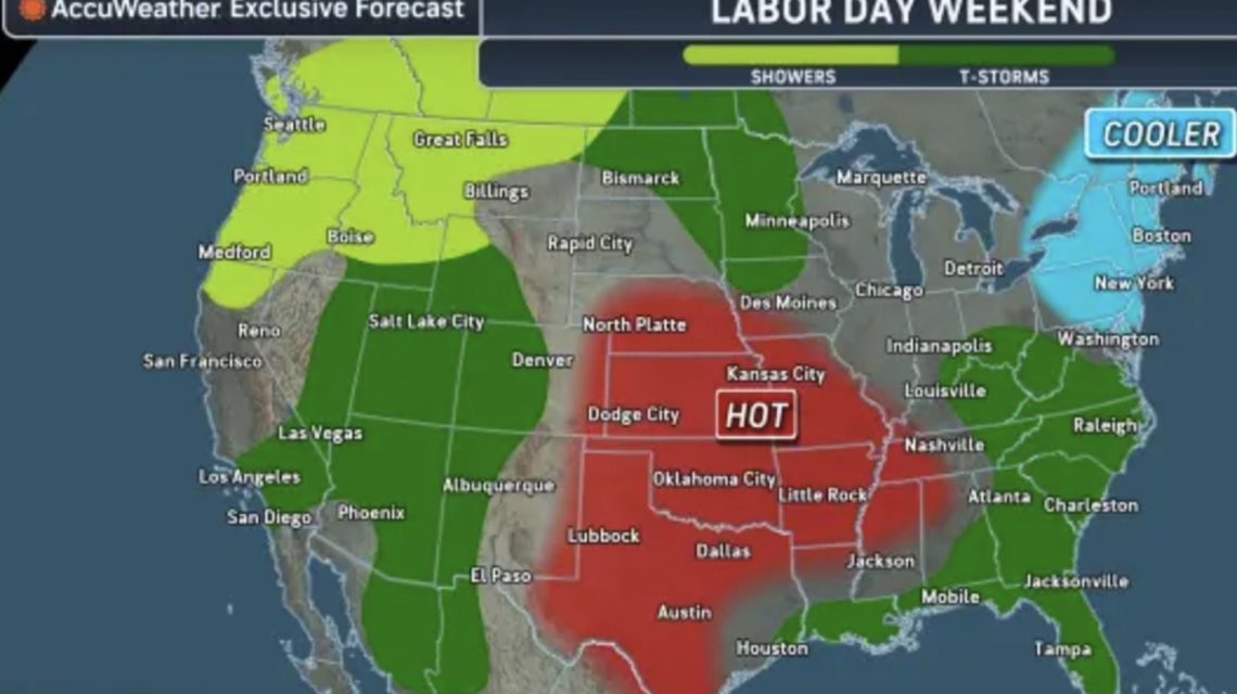
Two contrasting weather extremes mark the upcoming Labor Day weekend. Parts of the central United States will experience severe heat, while powerful storms may lead to flash flooding from the West to the Southeast.
Extreme Heat in Central States
The National Weather Service (NWS) issued extreme heat warnings for areas across five states. High temperatures and humidity significantly increase the risk of heat-related illnesses.
AccuWeather forecasts a large heat dome to bring extreme temperatures to the central and southern Plains and the Mississippi Valley. Cities in states like Texas, Oklahoma, Missouri, Tennessee, and Nebraska may experience temperatures exceeding 100 degrees Fahrenheit. High humidity can make the conditions feel up to 15 degrees hotter.
The latest NWS forecast indicates increased heat across the middle Mississippi, Ohio, and Tennessee Valleys starting Wednesday. Heat advisories caution about dangerously hot conditions in these areas.
According to the NWS Weather Prediction Center, this warmth results from a persistent ridge of high pressure. Record warmth is expected to continue into early next week, with areas facing moderate to extreme heat risk.
Storms Encircle the Heat Dome
While the heat dome leads to dry conditions in the central U.S., showers and thunderstorms may occur around its perimeter. These storms will span parts of the West, northern Plains, Midwest, and Southeast, with potential for torrential downpours, flash flooding, and damaging winds.
The NWS predicts increased storm activity by Thursday, especially in the Southwest, Great Basin, and central and southern Rockies. The forecast also indicates showers from the lower Great Lakes to the northern mid-Atlantic.
Understanding Heat Domes
A heat dome forms when a high-pressure system traps heat and humidity over a region. This causes the air to sink and compress, raising lower atmosphere temperatures. The expanding hot air creates the dome effect, leading to prolonged heat waves.
Michael Muccilli, acting warning coordination meteorologist for NOAA’s Weather Prediction Center, previously explained to Newsweek that heat waves associated with these systems typically last one to two weeks, potentially longer in drought conditions.
Flood Risks in Texas
Forecasters anticipate increased flood risk in Texas following Tropical Storm Edouard, which transitioned to a tropical depression. Edouard is expected to bring heavy rain to eastern Texas, with flash flooding possible in urban areas, roads, small streams, and low-lying regions.
AccuWeather notes flash flooding concerns due to storms near the heat dome’s perimeter, especially in the West where thunderstorms may bring heavy rain.
 Fat Bear Week 2026 Highlights: Meet the Competitors
  Annual Fat Bear Week Begins at Katmai National Park
  Understanding Hurricane Development
  California Prepares for El Niño-Fueled Storms with Emergency Declaration
  California’s Growing EV Adoption: Challenges and Benefits
  Data Centers in Virginia face Growing Opposition