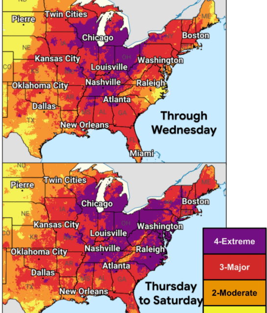
Communities in the central and eastern United States are experiencing the effects of a potentially deadly heat wave. This extreme heat poses a serious threat, especially as it combines with high humidity before the July Fourth holiday. The heat index, a measure of perceived temperature that factors in humidity, could reach between 105 and 115 degrees Fahrenheit, according to Nexstar Chief Meteorologist Brian James.
As of Tuesday, heat indices in the Midwest and South have already hit triple digits. Cities like Chicago and Minneapolis have experienced temperatures well above 100 degrees Fahrenheit.
Forecasters predict several days of high temperatures, with some exceeding 100 degrees Fahrenheit. These conditions will affect areas such as the lower Great Lakes, the mid-Atlantic, and the Mississippi and Ohio River valleys. According to National Weather Service meteorologist Bryan Putnam, record highs could be set in regions from the lower Great Lakes to New England later this week.
Major cities like New York, Philadelphia, Washington, and Baltimore on the East Coast will experience significant heat. Midwestern and Great Lakes cities such as Chicago, Indianapolis, St. Louis, and Detroit will also face high temperatures. Southern cities, including Dallas, Little Rock, Arkansas, and Memphis, Tennessee, will see similar conditions.
The National Weather Service has projected that several cities may break daily heat records this week.
Wednesday’s Expected Temperatures
- Binghamton, NY: 91°F (Previous Record: 90°F in 2018)
- Burlington, VT: 97°F (Previous Record: 96°F in 2018)
- Cleveland, OH: 97°F (Previous Record: 95°F in 2002)
- Washington Dulles, VA: 100°F (Previous Record: 96°F in 2012)
- Manchester, NH: 98°F (Previous Record: 97°F in 1971)
- Mount Pocono, PA: 90°F (Previous Record: 88°F in 2018)
- New Philadelphia, OH: 97°F (Previous Record: 96°F in 1991)
- Syracuse, NY: 97°F (Previous Record: 95°F in 1931)
- Youngstown, OH: 97°F (Previous Record: 96°F in 1931)
Thursday’s Expected Temperatures
- Albany, NY: 99°F (Previous Record: 98°F in 1966)
- Wilkes-Barre/Scranton, PA: 99°F (Previous Record: 98°F in 1966)
- Westfield/Springfield, MA: 102°F (Previous Record: 94°F in 2018)
- Hartford, CT: 102°F (Previous Record: 99°F in 1966)
- Binghamton, NY: 96°F (Previous Record: 92°F in 1966)
- Bangor, ME: 94°F (Previous Record: 93°F in 1941)
- Boston, MA: 101°F (Previous Record: 98°F in 1963)
- Burlington, VT: 99°F (Previous Record: 97°F in 2018)
- Charlottesville, VA: 104°F (Previous Record: 100°F in 1954)
- Cleveland, OH: 98°F (Previous Record: 97°F in 1954)
- Concord, NH: 102°F (Previous Record: 98°F in 1966)
- Washington, D.C. National Airport: 103°F (Previous Record: 101°F in 1898)
- Baltimore Downtown, MD: 104°F (Previous Record: 102°F in 1966)
- Newark, NJ: 104°F (Previous Record: 103°F in 1901)
- Glens Falls, NY: 97°F (Previous Record: 96°F in 1911)
- Washington Dulles, VA: 102°F (Previous Record: 98°F in 1966)
- Wilmington, DE: 100°F (Previous Record: 98°F in 1966)
- Williamsport, PA: 100°F (Previous Record: 99°F in 1966)
- Jackson, KY: 95°F (Previous Record: 93°F in 1991)
- Lynchburg, VA: 100°F (Previous Record: 99°F in 1898)
- New York LaGuardia Airport: 102°F (Previous Record: 101°F in 1966)
- Manchester, NH: 102°F (Previous Record: 95°F in 1968)
- New York City, NY: 102°F (Previous Record: 100°F in 1966)
- Philadelphia, PA: 104°F (Previous Record: 103°F in 1901)
- Poughkeepsie, NY: 102°F (Previous Record: 97°F in 1966)
- Providence, RI: 99°F (Previous Record: 98°F in 1941)
- Portland, ME: 99°F (Previous Record: 98°F in 1941)
- Roanoke, VA: 101°F (Previous Record: 100°F in 1954)
- Tri-Cities, TN: 99°F (Previous Record: 97°F in 1954)
- Trenton, NJ: 102°F (Previous Record: 100°F in 1901)
Friday’s Expected Temperatures
- Westfield/Springfield, MA: 100°F (Previous Record: 97°F in 2002)
- Bridgeport, CT: 100°F (Previous Record: 99°F in 1966)
- Barnwell, SC: 92°F (Previous Record: 90°F in 2007)
- Charlottesville, VA: 103°F (Previous Record: 100°F in 1966)
- Charlotte, NC: 100°F (Previous Record: 99°F in 1931)
- Danville, VA: 101°F (Previous Record: 100°F in 1955)
- Washington, D.C. National Airport: 104°F (Previous Record: 101°F in 1966)
- Baltimore Downtown, MD: 104°F (Previous Record: 102°F in 1997)
- Georgetown, DE: 103°F (Previous Record: 101°F in 1954)
- Greensboro, NC: 99°F (Previous Record: 98°F in 1911)
- Huntington, WV: 98°F (Previous Record: 97°F in 2012)
- Wilmington, DE: 103°F (Previous Record: 102°F in 1966)
- Williamsport, PA: 101°F (Previous Record: 100°F in 1966)
- Lynchburg, VA: 98°F (Previous Record: 97°F in 2012)
- Mansfield, OH: 95°F (Previous Record: 93°F in 2020)
- Manchester, NH: 100°F (Previous Record: 98°F in 2002)
- Annapolis, MD: 101°F (Previous Record: 100°F in 1901)
- Providence, RI: 99°F (Previous Record: 98°F in 2002)
- Portland, ME: 97°F (Previous Record: 95°F in 2002)
- Raleigh-Durham, NC: 102°F (Previous Record: 101°F in 2012)
- Richmond, VA: 101°F (Previous Record: 100°F in 1954)
- Roanoke, VA: 99°F (Previous Record: 97°F in 2012)
- Salisbury, MD: 101°F (Previous Record: 98°F in 1954)
- Tri-Cities, TN: 99°F (Previous Record: 96°F in 2018)
Saturday’s Expected Temperatures
- Barnwell, SC: 92°F (Previous Record: 89°F in 2025)
- Baltimore/Washington International, MD: 101°F (Previous Record: 100°F in 2002)
- Charlottesville, VA: 101°F (Previous Record: 100°F in 2012)
- Charlotte, NC: 100°F (Previous Record: 99°F in 1993)
- Danville, VA: 100°F (Previous Record: 99°F in 1919)
- Elkins, WV: 93°F (Previous Record: 92°F in 1911)
- New Bern, NC: 97°F (Previous Record: 95°F in 2023)
- Fayetteville, NC: 101°F (Previous Record: 98°F in 2019)
- Greensboro, NC: 99°F (Previous Record: 98°F in 1970)
- Washington Dulles, VA: 100°F (Previous Record: 97°F in 2002)
- Lynchburg, VA: 100°F (Previous Record: 98°F in 1966)
- Monterey, TN: 76°F (Previous Record: 75°F in 1928)
- Portland, ME: 97°F (Previous Record: 93°F in 2018)
- Raleigh-Durham, NC: 102°F (Previous Record: 101°F in 2024)
- Richmond, VA: 102°F (Previous Record: 100°F in 2002)
- Roanoke, VA: 100°F (Previous Record: 99°F in 1999)
- Tri-Cities, TN: 97°F (Previous Record: 95°F in 2024)
- Trenton, NJ: 100°F (Previous Record: 99°F in 2010)
Understanding a Heat Dome
The severe heat event is due to a ‘heat dome,’ a high-pressure system that traps warm air. Without vertical movement, there are fewer convective clouds and little chance for rain, according to NOAA. This leads to a continuous build-up of surface heat, experienced as a heat wave.
The high-pressure system also redirects storms, reducing the occurrence of cooling summer thunderstorms.
The National Weather Service advises checking on vulnerable individuals, including young children, older adults, those with chronic medical conditions, and pregnant women. It is crucial to stay hydrated, take breaks in the shade, limit outdoor activities, and never leave children or animals in unattended vehicles.
 Communities Continuing Recovery from Hurricane Helene Explored through Graphic Novel
  Fat Bear Week 2026 Highlights: Meet the Competitors
  Annual Fat Bear Week Begins at Katmai National Park
  Understanding Hurricane Development
  California Prepares for El Niño-Fueled Storms with Emergency Declaration
  California’s Growing EV Adoption: Challenges and Benefits