Low-Pressure Area and Potential Tropical Storm
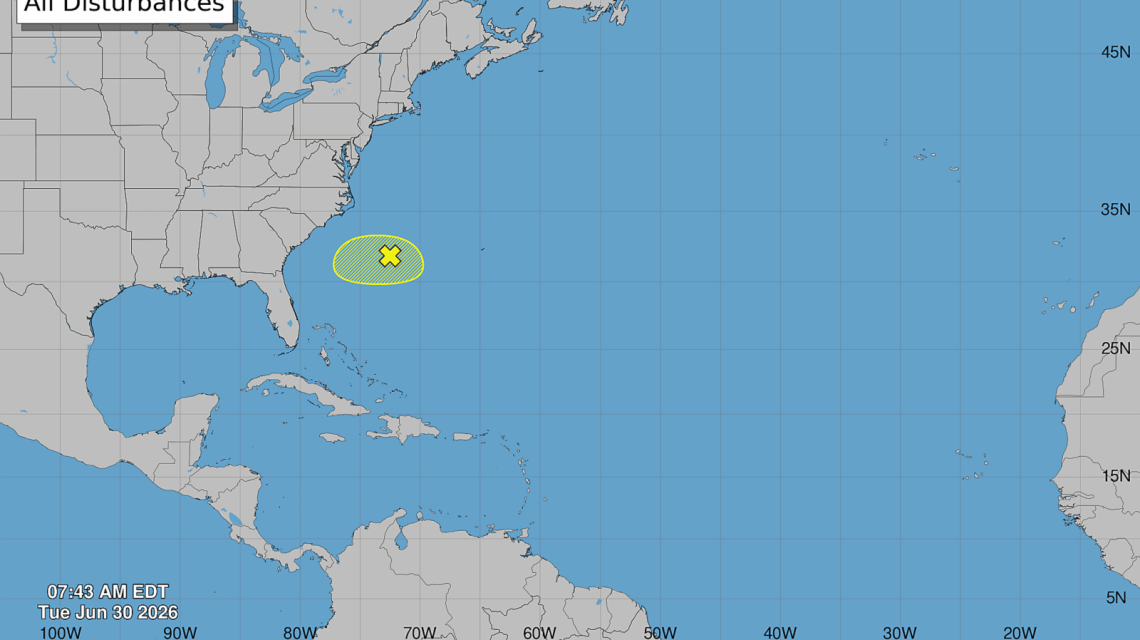
A low-pressure system off the southeastern U.S. coast may evolve into Tropical Storm Bertha this week. The system, currently drifting towards Florida, is under observation for tropical development.
Current Status and Forecast
The National Hurricane Center (NHC) reports that the disturbance, now offshore, remains disorganized and has a 10% chance of developing into a tropical system within the next 48 hours. Environmental conditions near Florida are not conducive to significant strengthening, but a more organized circulation might prompt naming it Bertha, marking it the second named storm of the 2026 season.
On Tuesday, the NHC noted the system’s southward movement, expecting a westward shift later in the week. AccuWeather’s lead expert, Alex DaSilva, suggests that if any tropical development occurs, it would be most likely on Wednesday or Thursday.
NOAA’s Seasonal Predictions
According to NOAA, this season is anticipated to be relatively quiet, with projections of eight to 14 named storms, including three to six hurricanes and one to three major hurricanes. Despite predictions of a less active season, significant landfalls remain possible. There’s a 55% chance of a below-normal season, primarily due to El Niño, which increases wind shear, making storm organization more challenging.
Typically, hurricanes require a stable atmosphere. However, strong upper-level winds linked with El Niño can disrupt storms, impeding the formation of hurricanes. Historically, El Niño years result in fewer Atlantic storms.
Challenges Facing the Disturbance
DaSilva explained to Newsweek that while wind shear is minimal, dry air from a cold front hinders development. Moreover, a heat dome over the Midwest and East Coast impacts air conditions, likely affecting the system.
The disturbance is forecasted to advance near the Gulf Stream in the coming days, a potential area for tropical depression development. DaSilva stressed the importance of monitoring this system, as changes off the East Coast can rapidly lead to storm formation.
Possible Developments and Safety Warnings
Should a tropical depression form, it might do so around July 1 or 2 when the system enters the warmer Gulf Stream waters. The primary risk involves increased rip currents along the East Coast from Florida to the Carolinas, expected to commence as early as Tuesday afternoon.
With regions experiencing a heat wave, beachgoers should exercise caution due to heightened rip current risks. Additionally, the NHC is observing a Pacific disturbance with an 80% chance of development within 48 hours.
 Data Centers in Virginia face Growing Opposition
  EPA Dismantles Greenhouse Gas Rules, Causing Concern
  How Battery Innovations Transform Renewable Energy
  Data Centers Stir Controversy in Texas Amid Growth Boom
  Urgent Archaeological Efforts in Quinhagak Stay Ahead of Erosion
  Concerns Rise Over NIPSCO Permit In Jasper County