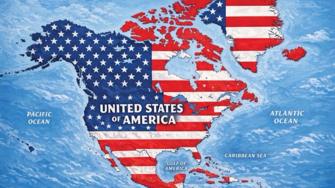
President Donald Trump shared an image on social media illustrating a greatly enlarged United States, which covers much of North America. The AI-generated map, posted on Truth Social, shows the U.S. flag superimposed on Canada, Mexico, Greenland, Cuba, and other nearby territories. This post included no caption, leaving its purpose unclear. The White House has made no indication that the map represents any official policy.
The map spans the North American continent, consisting of 23 sovereign nations, alongside Greenland, an autonomous territory of Denmark, and multiple Caribbean nations and regions. This aligns with Trump’s recent efforts to redefine the area’s political boundaries. Previously, Trump suggested Canada might become the 51st U.S. state and sought American control over Greenland. His administration has also increased tensions with Mexico and Cuba.
Newsweek contacted the White House on Monday for further remarks.
Reactions and Statements
Some nations depicted in the map have pushed back against Trump’s territorial ambitions. Canadian Prime Minister Mark Carney has repeatedly dismissed the notion of Canada joining the U.S. He told Trump during a May 6 Oval Office meeting, “As you know from real estate, there are some places that are not for sale.” Trump’s response was, “Never say never.”
Mexico has taken a firm stance against U.S. pressure. President Claudia Sheinbaum defended Mexico’s sovereignty amid disputes with Washington. Sheinbaum stated on X, “In the month of the homeland, we reaffirm that Mexico is neither nor will be a colony or protectorate of any foreign country. Proudly we are a free, independent, and sovereign nation.”
Cuba also countered Trump’s administration’s policies. Foreign Minister Bruno Rodríguez accused the U.S. of subjecting Cubans to “collective punishment.” He mentioned an energy blockade and intensified sanctions causing severe power outages. Rodríguez criticized Washington for restricting fuel supplies to Cuba.
Additional AI Images
On Sunday, Trump shared more AI-generated images, including one suggesting renaming New Mexico as “New America” and another declaring, “The Moon Is Ours.” Earlier this year, Trump ordered U.S. federal agencies to call the Gulf of Mexico the “Gulf of America.” This change is recognized only by the U.S. federal government. More recently, Trump declared that Lake Ontario would be renamed “Lake America,” amid an escalating trade dispute with Canada.
Expert Opinion
Craig Agranoff, a political professor at Florida Atlantic University, told Newsweek, “This looks more like messaging than a policy memo. President Trump often uses maps and renamed landmarks as political theater, and posting an image with no text is classic provocation rather than a formal claim. That said, countries should not treat it as empty noise.”
He continued, “When a sitting president overlays the American flag on Mexico, Canada, Iceland, Cuba, and Jamaica, allies and neighbors have to respond, because silence can be read as acceptance. The practical risk is not an overnight annexation. It is that the image becomes part of a pattern that complicates diplomacy, trade talks, and security cooperation. Foreign governments are right to take the symbolism seriously even if they do not treat the map as an operational plan.”
Countries and Territories Depicted
- Canada
- United States
- Greenland — autonomous territory within Denmark
- Iceland
- Mexico
- Belize
- Guatemala
- Honduras
- El Salvador
- Nicaragua
- Cuba
- Jamaica
- Haiti
- Dominican Republic
- Bahamas
- Puerto Rico — U.S. territory
- Cayman Islands — British Overseas Territory
- Antigua and Barbuda
- Saint Kitts and Nevis
- Dominica
- Saint Lucia
- Barbados
- Saint Vincent and the Grenadines
- Turks and Caicos Islands — British Overseas Territory
- British Virgin Islands — British Overseas Territory
- U.S. Virgin Islands — U.S. territory
- Saint-Martin — French overseas collectivity
- Sint Maarten — constituent country within the Kingdom of the Netherlands
- Anguilla — British Overseas Territory
- Saint Barthélemy — French overseas collectivity
- Montserrat — British Overseas Territory
- Guadeloupe — French overseas department and region
- Martinique — French territorial collectivity
- Grenada
Other Caribbean countries and territories like Trinidad and Tobago, Aruba, Bonaire, and Curacao are not visible on the map.
 Ukraine Missile and Drone Barrage Hits Russia Amidst Elections
  A Mother’s Tragic Journey Under Abortion Ban
  U.S. Strategic Goals Remain Unmet Amid Prolonged Conflict
  New Photos Reveal Damage from Iranian Strikes in the Middle East
  Assassin of Chilean Diplomat Orlando Letelier Faces Deportation 50 Years After Assassination
  Gorillaz and Macklemore Respond to Controversy Over Israel-Palestine Statements