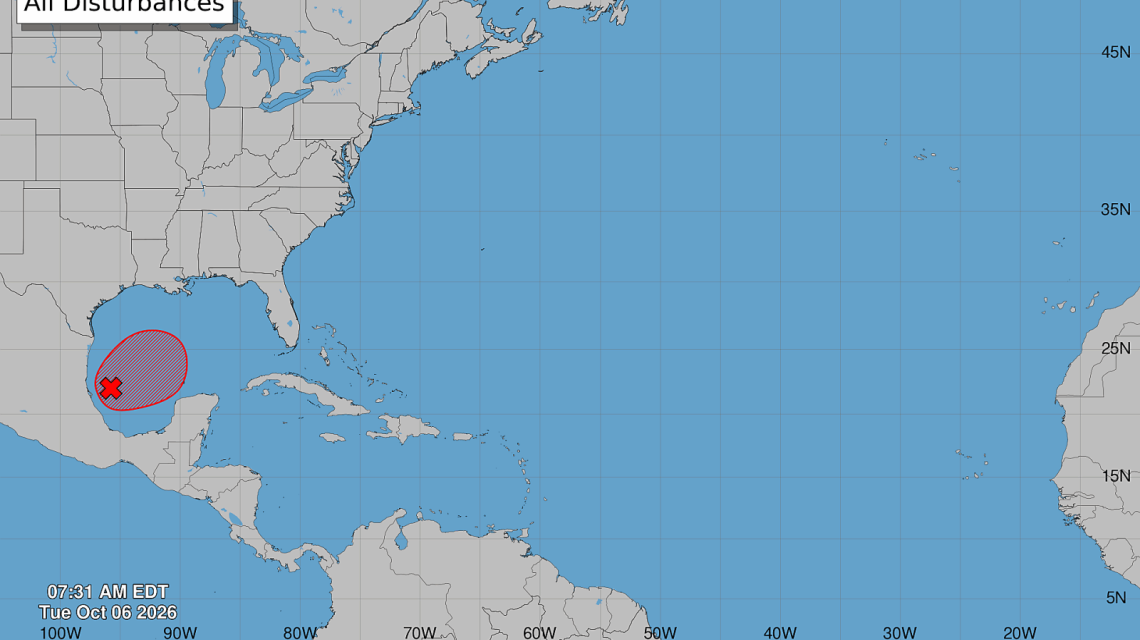
A tropical disturbance in the Gulf of Mexico is anticipated to evolve into Tropical Storm Isaias soon. Forecasters are watching its path as it moves toward the United States. This system may bring heavy rain, storm surge, damaging winds, and isolated tornadoes to the Gulf Coast later this week.
Residents from eastern Louisiana to the Florida Panhandle should stay updated as confidence grows that the storm will reach the northern Gulf Coast by Friday or Saturday. The National Hurricane Center monitors Invest 92L in the Bay of Campeche and has assigned it a high probability of tropical development. Hurricane Hunter aircraft will investigate the disturbance to assess its strength and landfall location. Current forecasts and models suggest the northern Gulf Coast has the highest risk.
Isaias Spaghetti Models Indicate Gulf Coast Landfall
Recent spaghetti model guidance suggests several tracks across the northern Gulf Coast. Many predictions bring Isaias between eastern Louisiana and the Florida Panhandle. While models differ on the exact point of landfall, consensus grows for this region. Meteorologist Matt Devitt emphasized a high potential for landfall from eastern Louisiana to the Florida Panhandle.
AccuWeather Lead Hurricane Meteorologist Alex DaSilva shared that chances of the storm stalling in the Bay of Campeche are diminishing. The highest risk is currently projected for coastal Mississippi and Alabama, with potential landfall east of Biloxi, MS, on Saturday morning. Further confidence in timing and location will increase as a defined circulation develops.
Though there remains some uncertainty about where the storm’s center will form and organize, many forecast tracks have shifted toward the U.S. Gulf Coast. The spaghetti models display a range of possible paths, and areas east or west of the center can still experience hazardous weather if the storm develops an asymmetric structure.
Possible Landfall Locations
Forecast steering currents suggest the disturbance will move generally north-northeast across the Gulf. Prevailing winds favor a track towards the central Gulf Coast. Projections place the highest probability of landfall near southeastern Louisiana, coastal Mississippi, Alabama’s shoreline, or the Florida Panhandle.
Even small track adjustments could shift the area of greatest impacts significantly. The storm’s future path depends on variables like its circulation center, surrounding atmospheric conditions, and rapidity of strengthening over water. Tropical hazards frequently extend far from the point of landfall, especially on the eastern side.
Could Isaias Become a Hurricane?
Tropical development is likely, but Isaias’ potential strength remains under discussion. Gulf water temperatures are warm enough to support intensification, but wind shear could influence its intensity. DaSilva noted that while temperatures are conducive for strengthening, wind shear may prevent it from becoming significantly intense.
AccuWeather predicts Isaias could become a hurricane by Friday, although increasing wind shear near the northern Gulf Coast might weaken it before landfall. Hurricane Hunter aircraft will investigate for more environmental insights. A few scenarios still suggest a stronger cyclone, adding uncertainty to intensity forecasts compared to track forecasts.
Flooding, Rain, Storm Surge, and Tornado Threats
Water hazards could pose significant threats even if Isaias becomes a hurricane. Its potential structure may focus heavy rainfall east of the center, risking flash floods and rising rivers along the Gulf Coast. Rainfall totals might range from 1 to 4 inches, with higher local amounts. Some areas have faced repeated rainfall, heightening runoff risks.
Storm surges are a concern, as prolonged winds can push water inland, causing coastal flooding even if the storm isn’t strong. Forecasts indicate a broad swath of rain from the southern Gulf coast northward to Louisiana and the Florida Panhandle. Impacts could reach as far as Kentucky and West Virginia.
AccuWeather expects 8-12 inches of rain across southern Alabama and Mississippi, bringing risks of widespread flooding and mudslides. Strong winds up to 100 mph may occur near the storm’s center with potential power outages and property damage. Tornadoes are also possible, particularly east of the center, along with a storm surge near landfall.
National Hurricane Center’s Current Actions
The National Hurricane Center continues evaluating Invest 92L’s potential organization in the Gulf. Hurricane Hunter aircraft recon are expected to yield a clearer storm profile for modeling forecasts. If the disturbance achieves tropical-storm criteria, it will be named Isaias, marking the ninth named storm of 2026.
As monitoring continues, residents along the Gulf Coast should review emergency plans and ready supplies. Awareness of local evacuation zones is crucial in anticipation of possible evacuations. Being prepared is better than being caught by surprise.
 Coyotes Caught on Camera at Southern California Cabin
  Advancements in Nuclear Power for America’s Energy Needs
  Tickborne Alpha-gal Syndrome Impacting Martha’s Vineyard
  Collapse of Holei Sea Arch on Hawaii’s Big Island
  Contentious Tax Incentives Spark Debate Over Iowa Steel Plant
  Evaluating the Choice of Electric Vehicles Amid Rising Fuel Costs