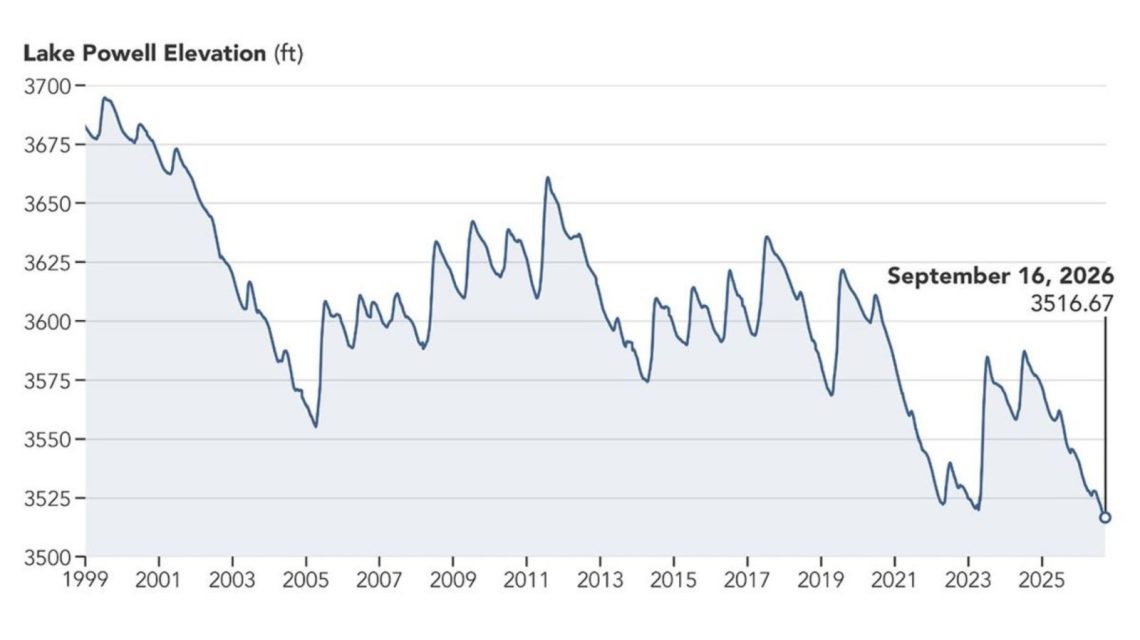
Recent satellite images reveal a significant decline in Lake Powell’s water levels over a nine-year period. These images compare the lake near Glen Canyon Dam on September 1, 2017, with the same area on September 10, 2026. This change follows a prolonged drought that has contributed to the reservoir reaching its lowest recorded level.
NASA described Lake Powell’s 2017 water level as one of the highest of the preceding decade. By September 10, 2026, substantially less water was evident, with levels at 3,517.24 feet—this was roughly a month after the levels dropped below the previous record low of 3,519.92 feet set in April 2023.
Importance of Lake Powell and the Colorado River System
Lake Powell is the second-largest reservoir in the United States, located along the drought-stricken Colorado River. This river runs approximately 1,400 miles, providing vital resources for seven states: Arizona, California, Colorado, Nevada, New Mexico, Utah, and Wyoming, as well as Mexico.
The Colorado River is crucial for municipal water supplies for millions of people. It also supports hydropower, recreation, fish and wildlife, and agricultural land.
Record Lows in Major Colorado River Reservoirs
The release of these images by NASA comes after both Lake Powell and Lake Mead—the largest reservoir in the U.S.—hit record lows in August. The Bureau of Reclamation reported these lows following a record-low winter snowpack in the Colorado River Basin during the 2025-2026 winter.
Sarah Porter, director of the Kyl Center for Water Policy at Arizona State University, noted that Mead’s record low was unfortunate yet expected. She emphasized that one good winter snowpack could improve the situation temporarily, but long-term stabilization would require more than that. Federal water managers announced measures to help bolster Lake Powell’s levels, such as releasing water from Flaming Gorge Reservoir upstream and reducing releases downstream to Lake Mead.
The Bureau of Reclamation warned that without significant intervention, declining water levels at Lake Powell could threaten hydropower production at Glen Canyon Dam.
Potential Increase in Lake Powell Levels
New federal projections suggest Lake Powell’s levels might rise by 40 feet over the next two years. However, projections also indicate that Lake Mead’s levels could decrease by a similar amount. The Bureau of Reclamation’s September 2026 “most probable” 24-Month Study, which includes plans to release 6 million acre-feet of water from Lake Powell in the 2027 operating year, expects Lake Powell to rise to 3,558.44 feet by June 2028. Conversely, Lake Mead could drop to 998.40 feet by August that year.
For further information, please contact the Newsweek editor, Edward Pearcey.
 Texas’s New Tallest Skyscraper: Waterline Marks Architectural Progress
  Transforming Faaborg Family Farm from Hogs to Mushrooms
  Great Lakes Face Beach Hazards Due to Dangerous Currents
  Surprising Encounter with Gulf Sturgeon in the Suwannee River
  Potential Impact of Tropical Storm Polo on Southern California
  Communities Continuing Recovery from Hurricane Helene Explored through Graphic Novel