Hurricane Karina Strengthens in the Pacific
Hurricane Karina has become a formidable Category 4 storm in the eastern Pacific. Although the hurricane will not move towards California, swells generated by Karina are expected to travel north, potentially creating dangerous surf and rip currents along the Southern California coast.
Swells from Karina will impact southwest Mexico and Baja California’s coast over the coming days, spreading north to Southern California between Monday and midweek, as stated in an advisory from NOAA’s National Hurricane Center (NHC).
The hurricane is advancing westward, further into the Pacific, away from California. This movement means the threat in California comes from swells that can travel long distances ahead of and away from the storm.
Current Position and Strength of Hurricane Karina
Late Sunday, Hurricane Karina was positioned approximately 1,020 miles (1,640 kilometers) west-southwest of Baja California’s southern tip, with maximum sustained winds of 145 mph, moving west at 9 mph according to the NHC. There are no coastal watches or warnings currently in effect.
NOAA was contacted by Newsweek via email for further comments on the situation.
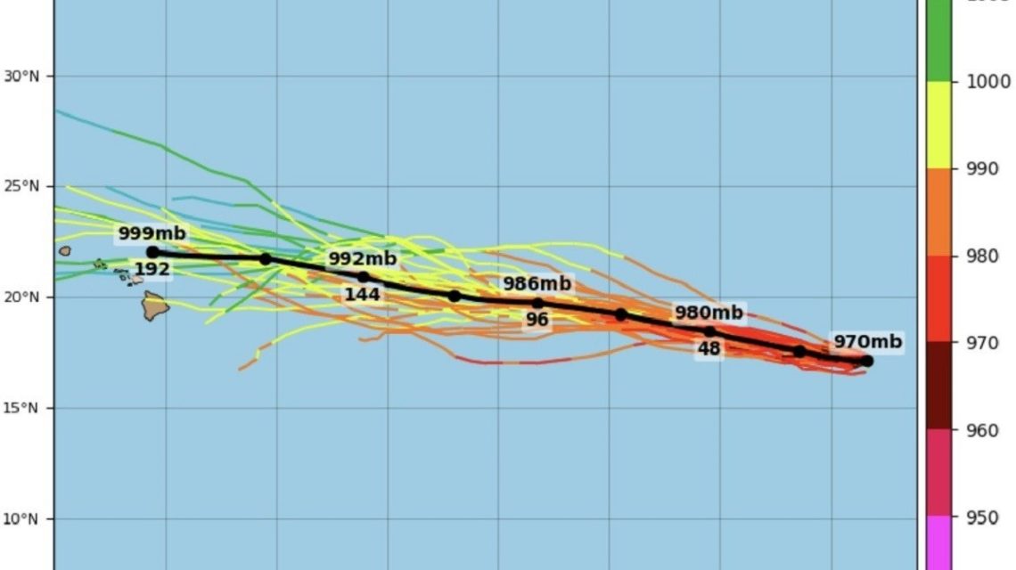
Karina’s Forecasted Path Using Spaghetti Models
The spaghetti-model guidance from Tropical Tidbits indicates Karina will continue moving westward over the open Pacific. The forecasts show the hurricane’s center remaining offshore of Mexico and California.
Spaghetti models utilize different acronyms to describe hurricane dynamics:
- GEFS: Global Ensemble Forecast System, providing varied storm track forecasts.
- Tracks: Predicted paths of the storm’s center from diverse forecasts.
- MSLP: Minimum mean sea level pressure, denoting the lowest atmospheric pressure expected.
- Mb and hPa: Measuring units for atmospheric pressure, where a lower MSLP signifies a more potent storm.
Potential Surf Conditions in Southern California
According to the NHC’s recent forecast, Karina will keep moving west on Monday before shifting west-northwest by Tuesday, remaining over Pacific waters. Swells generated by the hurricane are anticipated to reach the Southern California coast from Monday through the middle of the week.
These swells could lead to hazardous surf and rip-current conditions, as highlighted by the NHC’s warning.
Hurricane Karina’s Continuing Offshore Path
The storm’s center was near 17.2 degrees north latitude and 124.4 degrees west longitude at 0900 UTC on Monday, moving west at about 8 knots. Maximum sustained winds reached 125 knots with gusts up to 150 knots, according to the NHC. Further strengthening may occur, followed by variations in intensity throughout the week.
Precautions for Beach Visitors
Individuals heading to Southern California beaches should monitor the latest forecasts and local advisories regarding surf conditions as swells approach. The NHC has urged beachgoers to stay informed by regularly checking updates from their local weather offices.
 Potential Impact of Tropical Storm Polo on Southern California
  Google Fined for Breaching EU Privacy Rules
  South China Sea Tensions Rise after Collision between Chinese and Philippine Ships
  North Korea’s Hypersonic Weapon Test Amid Global Tensions
  Austin Tice: A Search for Answers
  U.S., Denmark, and Greenland Forge New Security Agreement