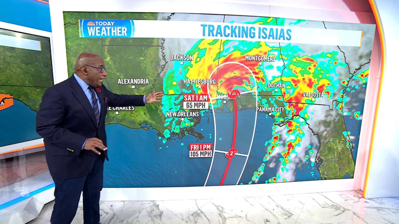
Intensification of Hurricane Isaias
Hurricane Isaias has intensified significantly over the past 24 hours. What was once a 40 mph tropical storm is now an 80 mph Category 1 hurricane, showing how quickly conditions can change. As of now, the hurricane is 385 miles south-southwest of the Mississippi River’s mouth, moving east-northeast at 9 mph.
Warnings are in place across the northern Gulf Coast, highlighting the seriousness of the situation. Hurricane-force winds are affecting areas up to 15 miles from the center, while tropical storm-force winds are impacting areas as far as 90 miles from the center. Forecasters expect Isaias to reach Category 2 status by early tomorrow morning, continuing its rapid path.
Storm Surge and Rainfall Predictions
Storm surge warnings and flooding predictions are crucial for several regions:
- Ocean Springs, MS, to Indian Pass, FL: 5-7 feet
- Mobile Bay, AL: 5-7 feet
- Mouth of the Mississippi River, LA, to Ocean Springs, MS: 5 feet
- Indian Pass, FL, to Steinhatchee River, FL: 4-6 feet
- Steinhatchee River, FL, to Yankeetown, FL: 2-4 feet
- Lake Pontchartrain, LA: 1-3 feet
Rainfall totals are expected to be substantial, with southeastern Louisiana to the western Florida Panhandle anticipating 3-7 inches and locally higher amounts around 10 inches. The Tennessee Valley, Southeast, and Carolinas might see 1-3 inches, with local areas experiencing up to 5 inches. Washington to New York City could see 1-2 inches of rain.
Tornado Threat
There’s a possibility of isolated tornadoes occurring from Friday night through Saturday. Areas at risk include coastal Alabama, the Florida Panhandle, and far southwestern Georgia. On Saturday, the threat shifts to eastern Alabama, Georgia, and northern Florida. The potential for tornado outbreaks could rise as forecasts develop.
Preparedness for Landfall
Isaias’s current trajectory suggests landfall late tomorrow night or early Saturday morning between Mobile and Panama City, close to or over Pensacola. It is expected that the hurricane will weaken as it approaches landfall; however, with this weakening, the storm’s wind field will broaden. This increases the risk of tree damage and power outages as the hurricane moves inland.
Cities like Montgomery, Birmingham, Huntsville, Nashville, and Memphis should remain alert for strong winds, as Isaias will continue its rapid movement coastward. Although strong winds might reach far inland, they will last a brief period before conditions start improving as the storm moves onward.
Impact on Oil Production
In preparation for the storm, oil and gas companies have shut down around 25% of offshore production in the Gulf. This accounts for about 511,000 barrels a day being temporarily removed from the market as production halts. Such measures come as a proactive response to safeguard equipment and personnel.
This shutdown involves evacuating eight of the Gulf’s 371 manned oil platforms. Although production cuts could impact market prices, previous hurricanes have caused more significant disruptions. The risk to oil markets could rise substantially if the hurricane hits refineries directly.
 U.S. Forces in Japan Face Curfew Following Marine’s Arrest
  Grief and Resilience: Remembering Hersh Goldberg-Polin and the Aftermath of the October 7 Attacks
  Zion Teasley Pleads Guilty to Murder of Lauren Heike
  Concerns Rise Over Working Conditions at Fuyao Glass America Inc.
  Investigation into Lineage Warehouse Fire in Boyle Heights
  Cornell University’s Faculty Considers No-Confidence Vote Amid Allegations