Tropical Depression Edouard Brings Rain and Flood Risks
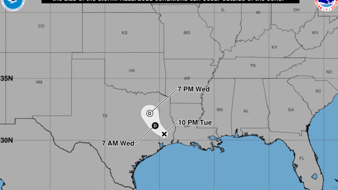
Tropical Storm Edouard has weakened to a tropical depression as it moves inland from the Gulf Coast, but heavy rain and flooding remain significant threats in Texas. Forecasts highlight potential flash flooding across the state due to widespread rainfall.
Storm Path and Rainfall Predictions
The latest projections show Edouard moving northward through eastern and central Texas. The primary corridor of heavy rain stretches from the upper Texas coast inward. While exact paths vary, forecasts indicate a broad impact zone from the Gulf Coast through eastern and central Texas, with these areas facing the highest flood risks.
Shift in Weather Threats
According to the National Hurricane Center (NHC), tropical storm wind gusts up to 73 mph are possible near the storm’s center. However, heavy rainfall has become the main concern. The NHC warns of likely river and flash flooding from the upper Texas coast to east-central Texas and southwest Louisiana.
Community Preparations in Southeast Texas
Local officials in southeast Texas are preparing for Edouard’s effects. In Montgomery County, emergency managers have mobilized resources like rescue boats and coordinated with state partners in anticipation of flooding. Schools in areas such as Conroe ISD and Willis ISD canceled Wednesday classes. Several government offices also closed. Jason Millsaps from the Montgomery County Office of Homeland Security emphasized concern over rain bands that can deposit large amounts of rainfall quickly. Barricades are set up in flood-prone areas.
Flood Watches Across Texas
The National Weather Service (NWS) has issued Flood Watches covering northeast, east-central, and southeast Texas. Forecasts for Henderson County and neighboring areas predict 1 to 3 inches of rain with possible isolated totals of up to 6 inches. Excess runoff may flood rivers and low-lying regions.
In southern and eastern Texas, including counties like Brazos and Harris, a wider Flood Watch anticipates more severe impacts. Rainfall totals of 3 to 6 inches are predicted, with isolated areas potentially receiving 10 to 15 inches, especially along and east of Interstate 45.
Ongoing Concerns and Safety Advisories
Edouard’s remnants are expected to move further inland through Thursday, continuing to bring rain across eastern Texas. Flood risks linger even after the storm weakens due to saturated grounds. Emergency officials urge residents to monitor forecasts and observe flood advisories if conditions worsen. A standing safety reminder is to avoid driving through flooded areas, as water depth can be misleading and dangerous.
Governor Greg Abbott’s office shared an August 31 press release detailing the state’s preparations against Edouard’s weather challenges, emphasizing readiness for adverse weather impacts.
Conclusion
Texans face significant threats from Edouard, primarily from flooding rather than wind. Forecasts warn that the storm’s heavy rains could lead to severe flooding of roads and neighborhoods.
 Gen Z’s Early Workforce Success Compared to Millennials
  NTSB Launches National Campaign for Railworker Safety in Chicago
  Staten Island Event Sparks Controversy Over Mayor’s Presence
  Maryland Hunter Charged After Fatal Shooting in Delaware
  The Push for Permanent Daylight Saving Time
  Mayor Zohran Mamdani Faces Backlash at Pro-Police Event