Pacific Ocean Hurricanes Pose Flood Threat to Southwest U.S.
Three hurricanes, Polo, Nolo, and Odalys, are active in the Pacific Ocean. Forecasts from the National Hurricane Center (NHC) indicate these storms might lead to heavy rainfall and flash flooding in the southwestern United States in the coming days.
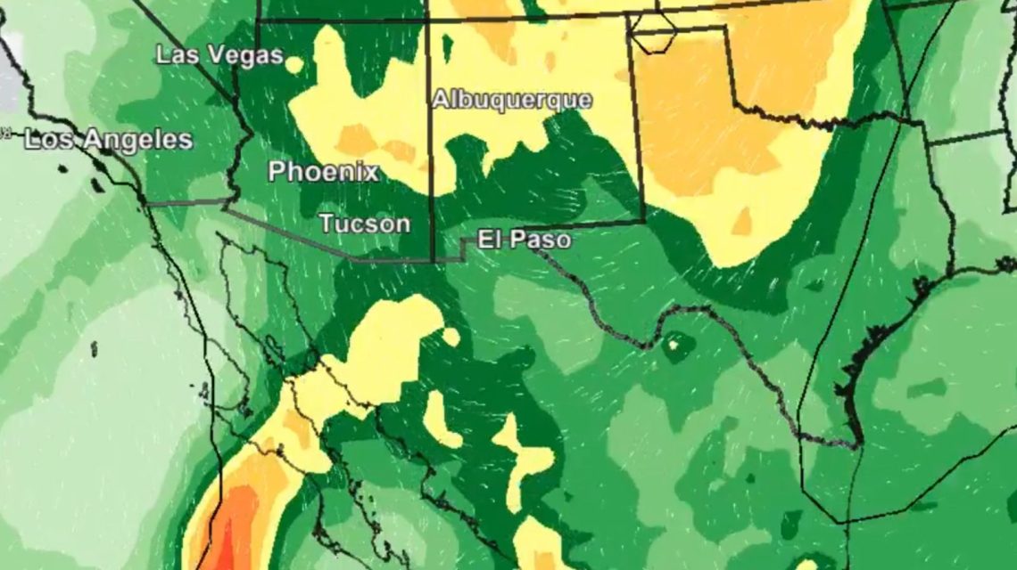
A map by the National Weather Service (NWS) in Phoenix shows a significant increase in rainfall probability across Arizona, New Mexico, northern Texas, and into Oklahoma, Colorado, and Kansas on Wednesday and Thursday.
The NWS Phoenix emphasizes the potential for widespread heavy rain in the Desert Southwest due to interactions between weather systems and moisture from Hurricanes Polo and Odalys. This increases flash flooding risks significantly.
Hurricane Polo is predicted to make landfall in Baja California Sur, Mexico, potentially causing life-threatening flooding and mudslides from Sunday onward. It is also expected to generate hazardous surf and rip currents along parts of the northwest coast of Mexico and Baja California.
Polo’s current maximum sustained winds are 155 miles per hour, classifying it as a category four hurricane, moving west-northwest at about nine miles per hour.
Hurricane Odalys
Located slightly to the north of Polo, Hurricane Odalys has winds reaching 105 miles per hour and moves north at seven miles per hour. Predictions suggest Odalys’ swells will affect the southwestern U.S., overlapping with Polo’s influence.
This year’s El Niño climate pattern has boosted hurricane activity in the Pacific, raising water temperatures near the equator, thus fostering hurricane development.
Hurricane Nolo Near Hawaii
Further west, Hurricane Nolo, with winds of 105 miles per hour, is positioned south of Hawaii, creating tropical storm conditions. Areas with steep terrain could experience hurricane conditions by today.
Upgraded to hurricane status, Nolo could bring heavy rain to the Big Island and eastern Maui over the weekend, risking significant flooding and mudslides, especially in steep southern and eastern areas. Gusty winds are likely across the Hawaiian Islands through the weekend.
Nor’easter Expected on U.S. East Coast
Meanwhile, the National Weather Service’s Weather Prediction Center anticipates a strong Nor’easter along the North American East Coast. The storm is expected to intensify off the Mid-Atlantic Coast before impacting New Jersey late Saturday and into Sunday.
Residents should prepare for major coastal flooding along the Mid-Atlantic Coast over several high tide cycles. Roads in low-lying areas might flood, affecting homes and businesses in Southern New England and the Carolinas.
The Nor’easter could bring gale-force winds to much of the U.S. East Coast, with gusts between 45-65 miles per hour posing a risk of power outages for Eastern Long Island and Southwestern New England.
 Starbucks to Shut Down 250 Stores in North America
  President Trump’s Visit to the Presidents Cup in Medinah
  Susie Wiles Opens Up About Battling Cancer While Leading White House Staff
  Emergency Response in Hawaii After Flight Crew Falls Ill
  CTA’s Green Line Experiences Wheel Misalignment Incident
  Michigan Man Stands Firm Amid Backlash Over Comments on Islamic Population