The Floating Island Mystery
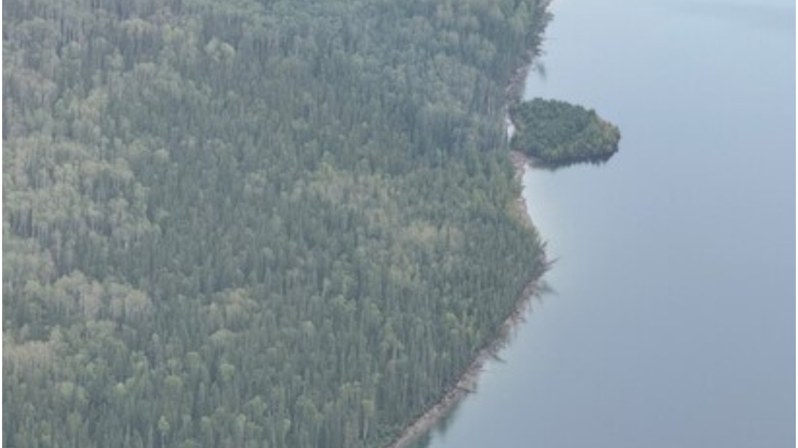
A floating island on British Columbia’s Williston Reservoir, initially baffling observers due to its disappearance, has been located. The island drifted roughly 30 kilometers over a 15-day period before it was found along the shoreline of the reservoir’s Ospika Arm.
BC Hydro spokesperson Bob Gammer highlighted the lack of eyewitness sightings for weeks, sparking international curiosity and speculation about the floating landmass.
Discovery Process
The island did not vanish but relocated across the reservoir. BC Hydro utilized satellite imagery, observations from aircraft, and boater reports to confirm its resting place against the shoreline.
A social media update by BC Hydro clarified, “We found the island. Turns out it wasn’t missing, just drifting.”
Timeline of Events
The mystery began with a satellite capture on July 21 showing the tree-covered island near Finlay Bay on the reservoir. Reports from local boaters emerged on August 13, but the island had moved from its original site.
Subsequent satellite imagery from August 15 revealed the island on the Ospika Arm, 30 kilometers from its first document location. BC Hydro confirmed its presence on August 31 and announced the finding on September 2.
Understanding Floating Islands
A floating island consists of vegetation, soil, and organic material floating on water. While smaller variants exist globally in lakes and wetlands, larger islands supporting mature trees are uncommon.
The formation theory suggests logs and woody debris gathered over years, decomposing until vegetation took root and created a stable, tree-supporting mass.
Geologists, ecologists, and researchers are intrigued by the floating island, seeking to unravel its formation and movement.
Island’s Journey
BC Hydro’s assessment shows the island traveled approximately 30 kilometers from its initial document location. The August 15 satellite images confirmed its movement near Ospika Arm.
Since satellite images are not live, the discovery confirmation took weeks.
The island’s new location, farther from the W.A.C. Bennett Dam, poses no expected operational impacts for BC Hydro.
Island’s Size
BC Hydro estimates the island spans 459 feet in length and 230 feet in width, covering about 9,800 square meters, equivalent to two NFL football fields. The island supports mature trees along with dense vegetation.
Images from BC Hydro show a landmass with the typical appearance of an island despite its mobility.
Visitation Guidelines
BC Hydro permits photographing the island from a distance using boats or drones. Landing on the unstable island, primarily composed of logs and decaying debris, is strongly discouraged due to safety concerns.
Gammer remarked on the discovery, “Finding the island has answered one question, but raised several others.” BC Hydro will continue monitoring the island as researchers delve deeper into this natural phenomenon.
 How Battery Innovations Transform Renewable Energy
  Data Centers Stir Controversy in Texas Amid Growth Boom
  Urgent Archaeological Efforts in Quinhagak Stay Ahead of Erosion
  Concerns Rise Over NIPSCO Permit In Jasper County
  Reader Reactions on Grizzlies and Data Centers
  Managing the Crisis of Drying Rivers