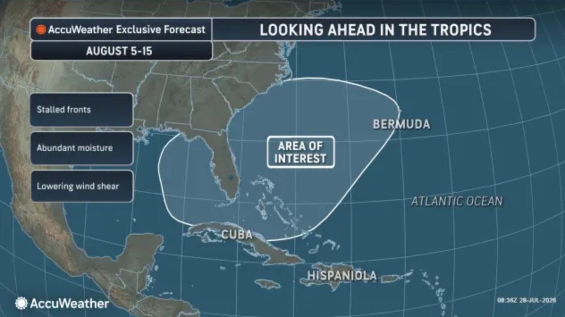
Waters around the southeastern U.S. might continue to be a significant focus for potential tropical weather system formations well into early and mid-August, as reported by AccuWeather. Currently, no immediate tropical activity follows the recent Bertha storm, but a broad region near the U.S. coastline might see increased susceptibility as the period progresses.
AccuWeather identifies the area of interest as encompassing waters around Florida, the Carolinas, Cuba, the Bahamas, and Bermuda. Later in the first and into the second week of August, this zone might yield the highest chance of developing a tropical depression or tropical rainstorm, although activity is unlikely during the month’s initial days.
Monitoring is underway because regional pressure is expected to be lower compared to adjacent areas, potentially aiding thunderstorm development. AccuWeather’s Lead Hurricane Expert, Alex DaSilva, suggested that approaching fronts could weaken over time, with warm waters sufficient for supporting tropical activity, and wind shear might temporarily decrease from summer levels.
“One possible development path includes a cluster of thunderstorms organizing into an area of low pressure, separating from a weakening front. This could lead to acquiring tropical characteristics, such as a warm core and rotation,” according to AccuWeather analysis.
The primary concern lies in the risk zone’s proximity to land. DaSilva highlighted the need for continuous monitoring due to possible “minimal notice” if a tropical storm emerges near the coast. Rapidly developing storms close to shore could bring sudden heavy rain, beach worsening, coastal flooding, and damaging winds.
This early-August alert follows Bertha, the second named storm of the 2026 Atlantic hurricane season, succeeding Arthur. The basin has yet to produce a hurricane this season.
Atlantic Hurricane Season Forecasts
AccuWeather projects a below-average to average Atlantic hurricane season, attributing the outlook to a strong El Niño, known to suppress Atlantic tropical activity. The National Oceanic and Atmospheric Administration (NOAA) echoes this with a May forecast, giving a 55% chance for a below-normal season, a 35% chance for a near-normal season, and a 10% chance for an above-normal season.
NOAA forecasts eight to 14 named storms, including three to six hurricanes and one to three major hurricanes, with 70% confidence in those ranges. An average Atlantic season usually sees 14 named storms, seven hurricanes, and three major hurricanes.
2026 Hurricane Season Storm Names
The official 2026 Atlantic storm-name list from the National Hurricane Center (NHC) includes: Arthur, Bertha, Cristobal, Dolly, Edouard, Fay, Gonzalo, Hanna, Isaias, Josephine, Kyle, Leah, Marco, Nana, Omar, Paulette, Rene, Sally, Teddy, Vicky, and Wilfred. As of Wednesday, the NHC reports no expected tropical cyclone activity in the Atlantic for the upcoming week.
 Communities Continuing Recovery from Hurricane Helene Explored through Graphic Novel
  Fat Bear Week 2026 Highlights: Meet the Competitors
  Annual Fat Bear Week Begins at Katmai National Park
  Understanding Hurricane Development
  California Prepares for El Niño-Fueled Storms with Emergency Declaration
  California’s Growing EV Adoption: Challenges and Benefits