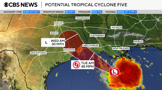
A tropical storm warning has been issued for coastal areas of Louisiana and Texas. This is due to the development of a potential tropical cyclone in the Gulf—marked as the fifth such system during the 2026 Atlantic hurricane season. The National Hurricane Center has temporarily named it Potential Tropical Cyclone Five, anticipating it will evolve into Tropical Storm Edouard.
Forecasters predict that the storm will bring significant rainfall. Coastal Texas and some eastern-central inland parts might receive 3 to 6 inches of rain. In some areas, rainfall could reach up to 9 inches. Southwestern Louisiana is expected to see about 2 to 3 inches, according to the National Hurricane Center.
The storm could lead to flash flooding in low-lying and urban regions as up to 3 feet of storm surge is possible in coastal areas. The warning zone includes regions from Port Bolivar in southeastern Texas to the Vermilion/Cameron Parish Line in southwestern Louisiana.
Tropical storm warnings are issued when strong winds, heavy rain, and potential flooding are expected within the warning region. In this case, these conditions are expected to manifest within 24 to 36 hours. The storm may impact the Gulf Coast by Tuesday.
On Monday morning, the storm was moving westward toward the Gulf Coast. It was located approximately 130 miles from Morgan City, Louisiana, and 230 miles from Port Arthur, Texas. At 11 a.m. ET, the system had maximum sustained winds of 35 mph. This speed was just below the 39 mph threshold required to classify a tropical storm. Forecasters expect the storm to gain strength over the next day.
 Nikole Hannah-Jones Reflects on Educational Choices for Her Daughter
  Life and Challenges at Chennai’s Kasimedu Fishing Harbour
  Chicago Bears Eye Potential Move to Indiana: A Look at the Developments
  Amazon Offers Discounts to Employees at Whole Foods
  Inside the American Airman Rescue Mission in Iran
  Trump Comments on China’s Surveillance Amid Reports of Aid to Iran