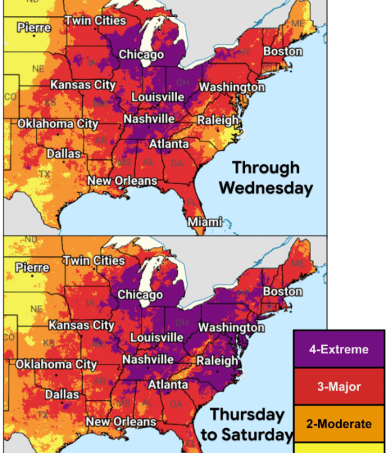
The central and eastern United States are facing a severe heat wave, posing significant health risks. Communities are experiencing dangerous temperatures as humidity rises in the lead-up to the July Fourth holiday.
Heat Index Concerns
According to Nexstar Chief Meteorologist Brian James, the heat index, which measures perceived temperature including humidity, may reach between 105 and 115 F. Early in the week, the Midwest and South observed triple-digit heat indices, with Chicago and Minneapolis surpassing 100°F.
Nexstar Chief Meteorologist Brian James reports possible heat index levels between 105 and 115 F.
Record-High Temperatures Predicted
The National Weather Service forecasts consecutive days of highs above 100°F in regions spanning the lower Great Lakes, mid-Atlantic, and the Mississippi and Ohio River valleys. NWS Meteorologist Bryan Putnam suggests possible record highs in these areas, observing that significant events, such as World Cup matches and celebrations for America’s 250th anniversary, are scheduled during this extreme heat.
Cities on the East Coast, such as New York, Philadelphia, Washington, and Baltimore, along with Midwestern and Great Lakes cities like Chicago, Indianapolis, and Detroit, will endure these heightened temperatures. The South, including Dallas, Little Rock, and Memphis, will also face scorching days.
Expected Daily Heat Records
The National Weather Service has identified several cities likely to experience record-breaking temperatures:
- Wednesday: Binghamton NY (91°F), Burlington VT (97°F), Cleveland OH (97°F), Washington Dulles VA (100°F).
- Thursday: Albany NY (99°F), Boston MA (101°F), Charlottesville VA (104°F), Washington D.C. (103°F).
- Friday: Bridgeport CT (100°F), Charlottesville VA (103°F), Georgetown DE (103°F), Washington D.C. (104°F).
- Saturday: Baltimore MD (101°F), Charlotte NC (100°F), Richmond VA (102°F), Raleigh-Durham NC (102°F).
Understanding the Heat Dome
This extreme heat stems from a ‘heat dome,’ a high-pressure system that traps heat by causing air to sink. The NOAA explains this effect limits convection, reducing cloud formation and rain prospects, leading to persistent surface heat.
The NOAA describes a heat dome as a high-pressure system trapping surface heat.
A heat dome diverts storms, reducing the likelihood of thunderstorms and consequently limiting natural cooling opportunities for the region.
Health Precautions
The NWS advises checking on vulnerable groups, including young children, older adults, the chronically ill, and pregnant women. Recommendations include staying hydrated, seeking shade during outdoor activities, minimizing strenuous tasks, and ensuring children and animals are never left unattended in vehicles.
 Nor’easter Threatens East Coast with Heavy Rain and Winds
  California’s Growing EV Adoption: Challenges and Benefits
  Understanding School Shooting Preparedness Drills
  Influencer Brothers Logan and Jake Paul Visit the Pentagon
  Florida Reports First Dengue Fever Death as Outbreak Expands
  American Public Opinion on Press Freedom