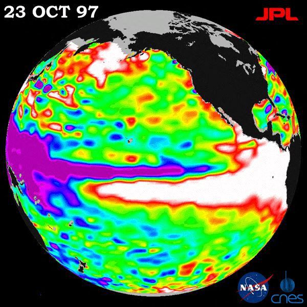
The El Niño phenomenon this year could become one of the most intense ever recorded. Climate experts suggest that current weather patterns may resemble those seen in 1997, a year marked by one of the strongest El Niños. According to Columbia University climate scientist Azhar Ehsan, the present atmospheric development shows similarities to 1997 when extraordinary weather extremes occurred.
The winter of 1997-1998 registered unprecedented weather records. As reported by the National Climatic Data Center in April 1998, this winter ranked as the second warmest and seventh wettest for the U.S. since record-keeping began in 1895. The powerful El Niño during this period sparked severe weather conditions across the nation.
Regions faced varying impacts. The Northeast experienced ice storms, while the Southeast and California faced intense flooding. Tornadoes also devastated parts of Florida. A 1997 NASA photo illustrated the influence of El Niño, showing warm water moving north along North America’s coast.
El Niño typically brings wetter conditions to the southern U.S. and warmer, drier conditions to the north. During the 1997-1998 winter, significant rainfall affected many areas. California and North Dakota saw their wettest winters on record. Florida, Maryland, Nevada, Rhode Island, and Virginia had their second wettest years.
December 1997 brought heavy rains to Florida, with Tampa receiving over 15 inches. January saw New Orleans with more than 19 inches, Mobile, Alabama, 17 inches, and Asheville, North Carolina, 10 inches. A major storm in January affected eastern North America, causing floods, tornadoes, and ice storms. Fifty-six people died in the U.S. and Canada, hundreds of homes were destroyed, and millions lost power.
By February, California and the Southwest experienced prolonged storminess, leading to mudslides and flooding. Certain regions saw little sun, with places like Des Moines experiencing 11 consecutive cloudy days, and Albuquerque, New Mexico, lacking sunlight before Christmas.
Unusually warm areas included Minnesota, Wisconsin, Illinois, Michigan, Ohio, Pennsylvania, and Connecticut, which recorded their warmest February. Notably, December 1997 saw no freezing temperatures in northern Montana cities. By the end of February, Lake Erie remained unfrozen, with temperatures near 36 degrees.
One benefit of the unusual weather was a 10% reduction in heating costs nationwide. With rising energy costs, such savings could offer relief in 2026.
Projections for 2026-2027 suggest an even stronger El Niño than in 1997-1998. It may trigger droughts in some regions and floods in others, potentially resulting in 451,000 weather-related global deaths. A strong El Niño often produces warm, dry northern conditions and cold, wet southern areas. The jet stream’s position affects this pattern annually.
This year’s El Niño, gaining momentum since summer, presents a 75% probability of surpassing past El Niño intensities since 1950. Though its peak typically occurs in winter, signs of influence appeared in late summer and early fall, including a subdued Atlantic hurricane season and active Pacific storm season.
Temperature and precipitation forecasts align with classic El Niño expectations for the remainder of the year.
 Elk Incident Captured on Viral Video in Colorado
  Trail Camera Captures Limping Bobcat, Signaling Recovery
  U.S. Records Warmest September on Record Since 1895
  States Lead in Energy Policy Amid Federal Setbacks
  The Impact of Modern Windows on Home Temperature Regulation
  Swiss Glaciers Continue Rapid Ice Loss Due to Global Warming