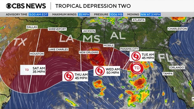
Tropical Storm Bertha has developed, becoming the second named storm of the Atlantic hurricane season. Positioned south of the Florida Panhandle, Bertha is moving west-northwest at 3 mph, with maximum sustained winds of 40 mph, as reported by the National Weather Service.
A map indicates the storm’s anticipated path, which follows the Gulf Coast from the Panhandle heading towards New Orleans and eventually eastern Texas later this week. Initially a tropical depression known as Tropical Depression Two, it transitioned into Tropical Storm Bertha.
A slow northwestward motion is expected through tonight, followed by a turn toward the west-northwest or west,” the weather service noted. “On the forecast track, the depression will move near or along the northern Gulf Coast during the next several days.
A Tropical Storm Watch stretches from the Ochlockonee River in Florida to the Jefferson/Plaquemines Parish border in Louisiana. Additionally, a Storm Surge Watch covers the area from the Alabama/Florida border to the mouth of the Mississippi River.
Forecasters caution against rainfall amounts reaching up to 8 inches in certain regions, which might lead to flash flooding. These rain conditions are expected to persist along the Gulf Coast and adjacent inland areas from western Florida to the Texas coast throughout the week. Areas in Alabama, Mississippi, and Louisiana are also projected to be affected.
The storm could result in storm surges, elevating water levels up to 4 feet at specific locations along the Gulf Coast. Bertha arrives weeks after the season’s first named storm, Tropical Storm Arthur, which hit the Gulf Coast of Texas in June.
 U.S. Strategic Goals Remain Unmet Amid Prolonged Conflict
  New Photos Reveal Damage from Iranian Strikes in the Middle East
  Assassin of Chilean Diplomat Orlando Letelier Faces Deportation 50 Years After Assassination
  Gorillaz and Macklemore Respond to Controversy Over Israel-Palestine Statements
  Investigation into Lion Deaths in Tanzania
  Merz Stays Resolute Amid Electoral Shifts in Germany